President Kennedy, son John Jr., and daughter Caroline - March 1963
President Kennedy began using Camp David regularly in the Spring of 1963. He had a bridle path cleared along the inside of the camp perimeter fence and a pony ring built for his daughter Caroline's pony, Macaroni. A stable was also built for the horses that First Lady Jacqueline Kennedy had arranged to be transported to the camp.
This 1963 newspaper article about a Presidential visit to Camp David reports that President Kennedy's helicopter "landed on a recreation field which had been temporarily converted into a riding ring for Mrs. Kennedy and five-year-old Caroline".
Susan and Steve Ford and friends rode horses at Camp David over Labor Day Weekend in 1974
The Reagans also enjoyed riding horses at Camp David. However, President Reagan was reportedly "appalled" to find that Richard Nixon had paved over many of the old riding trails so that he could ride around in a golf cart instead. Reagan had the trails restored and the National Park Service rangers brought in horses from nearby stables. Over time, the Reagans extended their rides to include some trails outside the camp perimeter fence.
President Reagan in 1983 Riding with Mexican President Jose Lopez Portillo in 1981
President Reagan and Vice President Bush ride horses at Camp David in July 1981
President and Mrs. Reagan, son Ron Reagan and wife Doria - October 1983
July 1984
In the book The Reagan Diaries, President Reagan wrote on October 3, 1981:
"Windy & cold but we rode & for the first time went out a back gate into the Catoctin National Forest. Followed an old road that led to a stone ruin of what was a summer hotel in 1933 when the lady owner Bessie Darling was murdered by her doctor boyfriend. During World War II it was used for briefing foreign intelligence officers. It's a tumbled ruin now."
I wanted to see if I could find the path President Reagan took that day out the back gate at Camp David to the ruin of the old hotel. According to the National Park Service website, Bessie Darling ran the old Valley View Manor. They have a map on their website that shows the location. A quick check on Google Earth revealed the Camp David back gate and a path that led into the direction of the old Valley View Manor. Below are some screen shots that show the back gate, the path to a clearing, and the ruins of Bessie Darling's house.
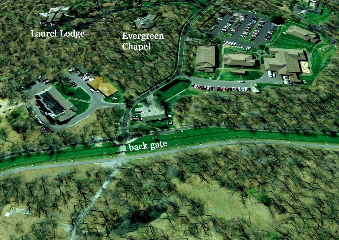
Camp David back gate
Trail leading out the back gate to a clearing. The Valley View Manor ruins are further past the clearing
I came across an interesting blog post written by someone who hiked to the Bessie Darling house on the Halloween anniversary of her murder. It is difficult to view the actual ruins on Google Maps since they are in a heavily wooded area. But who needs Google Maps when you have photos of the actual site?
Bessie Darling's house - The Valley View Manor Ruins of the house in 2008
The path from Camp David to the clearing is easily visible. The old road that President Reagan rode on past the clearing to the Bessie Darling House is obscured by trees. I could not find any documentation on the clearing or whether it is related to Camp David or not. Below are some close-ups of the clearing on Google Maps and Bing Maps.
Close up view of the clearing - from 2007 Google Maps
The 2007 image above shows the clearing on the way to the Valley View Manor. There appears to be a building on the left (see closeup view from different angle). The same area displayed in a more recent Bing Map below looks like there might be some construction going on in the area of the clearing.
View from Bing Maps - March 2012
I went back to Bing Maps a month later and noticed that the map image had changed and a prominent paved path leading to the back gate at Camp David was now visible.
In reference to the last part of this about Valley View Lodge and the construction going on at the site: have you by any chance ever heard of Raven Rock? Its a Continuity of Government complex run by the Defense Department located to the Northeast, just across the State Line, almost exactly 5 1/2 miles away.
There's a huge evidence gap here, and it could be something very mundane, but it would make alot of sense as to why there's a unnamed paved road leading from NSF-Thurmont toward the same direction as a semi-unacknowledged COG facility 5.5 miles away.
I wrote about the Raven Rock Mountain Complex in another post on this blog (http://aboutcampdavid.blogspot.com/2011/08/raven-rock-mountain-complex.html). The unnamed paved road appears to end at the area of the clearing. Perhaps the road continues towards Site R in an underground tunnel from that location. Or perhaps not...
I believe that the Cactus tower was concealed within a water tower. If you take a look at this old photo of Camp David from the JFK era, you can see the water in the distance. https://2.bp.blogspot.com/-4hr7Dd7GMxs/UKwkTZyEk0I/AAAAAAAACAw/jvzXWL-5wH4/s1600/camp-david-aerial-photo.jpg
Also, this old map shows the location of the water tower (labelled "water works") https://2.bp.blogspot.com/_7xEZf2ej1r8/TH9TS1UpWdI/AAAAAAAAAKw/PWtmoKo6MIk/s1600/camp-david-map.jpg
Hid in those woods in 1982-3 once at the furthest point. Reagan followed a trail that was a large circle that led only halfway down the side of the mountain. He rode with two female secret service agents. This was extra duty so got even less sleep during these equestrian events.


In reference to the last part of this about Valley View Lodge and the construction going on at the site: have you by any chance ever heard of Raven Rock? Its a Continuity of Government complex run by the Defense Department located to the Northeast, just across the State Line, almost exactly 5 1/2 miles away.
ReplyDelete(For reference:
http://en.wikipedia.org/wiki/Raven_Rock,_Pennsylvania)
There's a huge evidence gap here, and it could be something very mundane, but it would make alot of sense as to why there's a unnamed paved road leading from NSF-Thurmont toward the same direction as a semi-unacknowledged COG facility 5.5 miles away.
I wrote about the Raven Rock Mountain Complex in another post on this blog (http://aboutcampdavid.blogspot.com/2011/08/raven-rock-mountain-complex.html). The unnamed paved road appears to end at the area of the clearing. Perhaps the road continues towards Site R in an underground tunnel from that location. Or perhaps not...
DeleteAt one point there was a small arms range out the back gate where the Marines did familiarization firing with their assigned weapons.
ReplyDeleteFormer member of Marine Security Company, 1975 - 1976.
I always thought that the old microwave tower, with the small bunker, was in that clearing. Cactus.
ReplyDeleteI believe that the Cactus tower was concealed within a water tower. If you take a look at this old photo of Camp David from the JFK era, you can see the water in the distance. https://2.bp.blogspot.com/-4hr7Dd7GMxs/UKwkTZyEk0I/AAAAAAAACAw/jvzXWL-5wH4/s1600/camp-david-aerial-photo.jpg
DeleteAlso, this old map shows the location of the water tower (labelled "water works") https://2.bp.blogspot.com/_7xEZf2ej1r8/TH9TS1UpWdI/AAAAAAAAAKw/PWtmoKo6MIk/s1600/camp-david-map.jpg
In 1964, I was assigned to Ft Ritchie in the US Army & worked at 'The Rock' underground as a Cryptographer in the Comm Center.
ReplyDeleteHid in those woods in 1982-3 once at the furthest point. Reagan followed a trail that was a large circle that led only halfway down the side of the mountain. He rode with two female secret service agents. This was extra duty so got even less sleep during these equestrian events.
ReplyDelete